Lake Fire Burns 20,000+ Acres
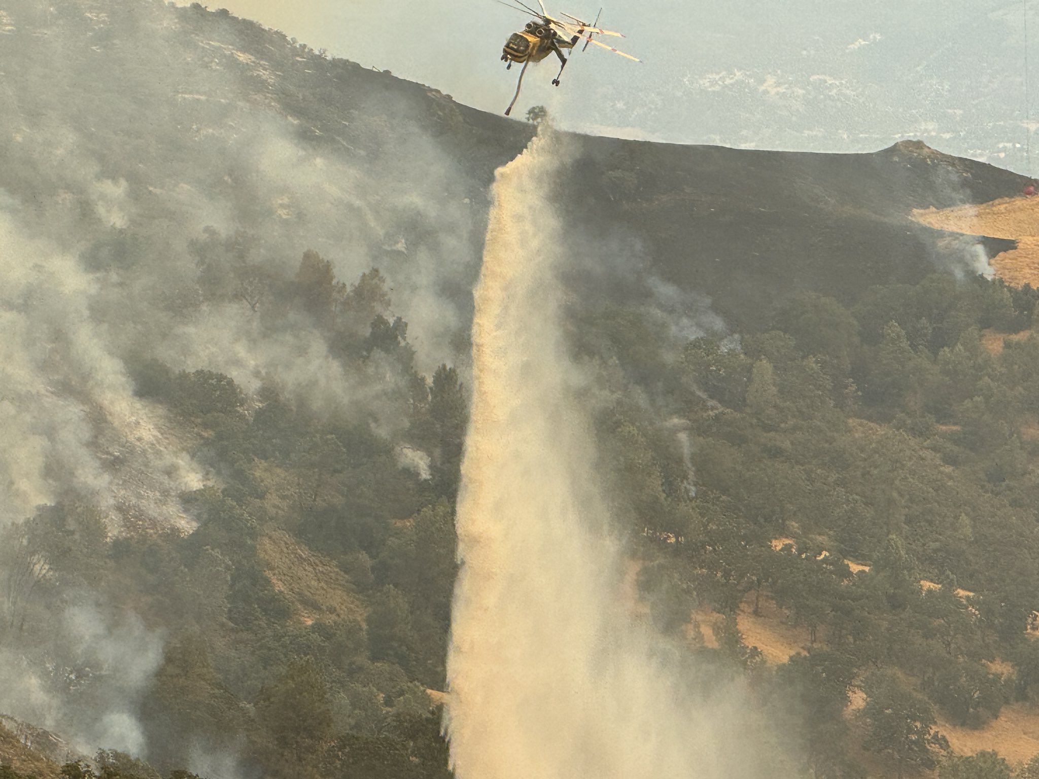
Photo credit: Courtesy of Scott Safechuck/SBC Fire Department
Story by Joyce Chi || Listen on SoundCloud
UPDATE (7/10/24, 6:15 PM): The following areas are under an EVACUATION ORDER:
- Woodstock Area (Areas north of Calzada Ave, east of E. Oak Trail Rd., west of Happy Canyon, and south of the Sisquoc River)
- Goat Rock Area (Area east of Figueroa Creek, north of the US Forest Service entrance at Happy Canyon Road, and south of Cachuma Mountain)
- SB Ranger area (remote forest area east of Goat Rock)
- Parts of the Figueroa Mountain area as follows: south of Tunnel House at Sisquoc River, east of Figueroa Creek, north of the southern end of Cachuma Mountain, and west of Los Padres National Forest areas
- All areas from Figueroa Mountain Road at Junction Camp (including Tunnel Rd) to Chamberlin Ranch and all areas from Zaca Lake Rd at Foxen Canyon Road north to the Sisquoc River including east of Foxen Canyon Road to the 9000 block.The following areas are under an EVACUATION WARNING:
- Area starting at the south end of Cachuma Creek, northeast of Santa Cruz Creek to Santa Cruz Peak, west through Grand Spring, and to the northern part of Cachuma Creek
- Area east and north of Alisos Rd (L-shaped road), west of Cachuma Creek, and south of the US Forest Service entrance at Happy Canyon Road
- Area east of Highway 154, north of Armour Ranch Road/Secretariate St, west of Alisos Rd, and south of the Woodstock area.
- Area east of Figueroa Mountain Road, north of Highway 154, west of Calzada Ave/W Oak Trail Rd and south of Woodstock Rd.
~~~
A fire broke out in Los Padres National Forest over the weekend, with reports of the fire first coming in around 3.45 p.m. on Friday, July 5th. Since then, the Lake Fire has grown to over 20,300 acres with 8% containment as of Monday, July 8th. It is the largest wildfire currently burning in California. To learn more about the Lake Fire, KCSB’s Joyce Chi spoke to Kelly Hubbard, director of the Santa Barbara County Office of Emergency Management.
HUBBARD: Yeah, Kelly Hubbard, I’m the Director for the Office of Emergency Management for the County of Santa Barbara.
CHI: Thanks so much for joining us today to talk about the Lake Fire. As of earlier today, July 8th, the fire has burned over 20,000 acres. First, could you describe a little bit like what the scene is like on the ground right now? How many firefighters are there? What kinds of challenges are they facing? Absolutely.
HUBBARD: Yeah, so the fire, as you mentioned, is well over 20,000 acres, only about 8% containment. The last personnel count that I got on the fire was over 1,000. I think even as I was leaving the incident command, there was more resources arriving, and so I think that number will continue to go up.
I think some of the challenges on the fire, I heard someone mention that they rate this as one of the most difficult ratings for a fire in terms of firefighting. And a couple of the complexities that I keep hearing is, one, the terrain. It’s steep, it goes up and down, and has lots of drop-offs, has different variables of different types of ecological features like oak trees that can fall, things like that.
But then also the fire goes through multiple elevations, and they’re actually having different weather effects at different elevations as well. So at the bottom of the fire, at the bottom of the hill, they have a marine layer in the morning, but it’s already 98 degrees on top. And then each of those canyons as they go around the fire have different wind patterns. And so it’s a really complex fire in terms of safety for firefighters and in terms of how they approach firefighting the fire.
CHI: And I know it’s still pretty early, the cause is still being investigated, but are there any potential standout theories you’re looking at right now?
HUBBARD: Not that it’s being discussed, no. Our focus is on fighting the fire and protection of lives of property.
CHI: There might have been some factors that might have contributed to how quickly the fire spread, things like especially the dry vegetation, if you could talk about that a little bit.
HUBBARD: Yeah, yeah, we had, you know, as everyone knows, we had a really wet winter season, and then it dried out really significantly. We had a heat wave going into this. We had excessive heat warnings. So both dry brush, dry, what we call dry fuels, which includes grasses and brush and those types of things. High heats, not a lot of humidity. All of those concepts contribute to how quickly the fire spreads, as well as the fact that the majority of this area has not burned. And I’ve heard anywhere between 17 to 20 years.
CHI: And you mentioned earlier that the focus right now is on protecting lives and property. Have there been any reported casualties or structural damage?
HUBBARD: No reported casualties. And in terms of structural damage, none that’s been reported to me. I know they continue to assess. So far the fire has burned mostly back into the forest area. We have some cabins back there and some like the park ranger station and the campground. And so I know the actual facilities and structures back there are still being assessed. And those have not been fully reported back in yet.
CHI: How are locals being impacted by this right now? Like, what is it like there for the neighboring towns?
HUBBARD: So we do have some areas that are under an evacuation order that that order only impacts A few residents and businesses and then the evacuation warning does impact quite a few more people. Somewhere, I think our number was around 200-300 homes. And so that evacuation warning though, when we’re in an area that is a warning, we highly recommend that you leave now if you have large animals, equine, cattle, or if you have pets. If you have any type of accessibility concerns, issues, any special needs, small children, it’s a good time to leave now.
If it’s going to take you a little bit longer to get out, don’t do that when it’s in the middle of the fire, really pressing down, right? We want to encourage those in the evacuation warning area to leave. Also, the air quality is really not great. And so, not a bad idea to not be in that area anyway. And then the community that is just below the fire — Santa Ynez, Los Alivos, all of that community there in the Santa Ynez Valley, all the way over to Solvang and Buellton — their quality has been impacted significantly and varied throughout the day.
And I know it’s even coming down into Santa Barbara and all the way up to Santa Maria. And so, we encourage residents to look at the Air Pollution Control District’s website, ourair.org, for more information on how to protect their health and also to monitor what their quality is.
CHI: What are the best and most up-to-date resources that you would recommend people to go to?
HUBBARD: The number one place I point anyone to is our county emergency website. So, that’s readysbc.org. And at the top, there’s a banner with red letterings. Click on that and it’ll take you to an incident page. And from there, we might point you to other websites like our county public works, roads, closures, Caltrans roads, closures.
We point you over back to that Air Pollution Control District website to the incident website, so that if you wanted very detailed information about firefighter personnel and those kinds of things, we point you back to that. But that’s kind of a one-stop shop. And then we have information about our evacuation shelter. If you need help with animal sheltering or evacuation of large animals, all of that information is right there in one space. And I think the last thing I would encourage everyone to do is to register for emergency alerts. That is the best way for us to get a hold of everybody. And so they can do that at that same website, readysbc.org.
If they are not comfortable with that or they’re… I know we’ve had a couple seniors call and say, I’m struggling with this website. We do have a call center open and that call center is for general information regarding the incident, but also if any residents want assistance in registering for emergency alerts, we can do that when they call the call center.
CHI: That was Kelly Hubbard, director of the Santa Barbara County Office of Emergency Management. The call center set up by the county is available in both English and Spanish from 9 a.m. to 7 p.m. for information about the lake fire and for resources for those impacted by the evacuation notices.
The number is 833-688-5551. Visit readysbc.org for more information about evacuation orders and warnings.
Evacuation orders are instructions to leave immediately while evacuation warnings say to be prepared to leave at any moment. Evacuation warnings are in place for surrounding areas while an evacuation order has been issued for all areas from Figueroa Mountain Road at Junction Camp, that’s including Tunnel Road, to Chamberlain Ranch. The evacuation order also applies to all areas from Zaka Lake Road at Fox and Canyon Road, north to the Sisquok River, including east of Fox and Canyon Road to the 9,000 block.